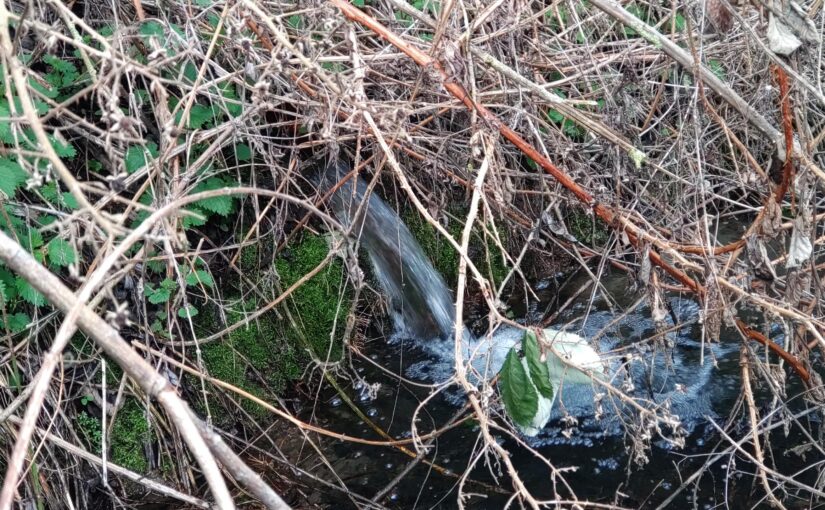
In February 2026, we were concerned to see a mysterious 4” hole gushing water under the eastern boundary fence from Haslingfield Sewage Works. This flowed into a ditch, then into the Rhee.
Despite the dry weather, the gusher was still flowing 10 days later. We were also concerned that the EDM storm overflow monitoring had gone offline on 24 February, having been previously showing an active storm overflow from 3 Feb- 23 Feb. Could these two things have been connected?
On 2 March 2026 we reported it to the Environment Agency and Anglian Water. We have also been investigating ourselves…
Our immediate concern was that it could be a leak from the Sewage works’ tanks, so we tested the “gusher” for E.coli. This showed that it had an E.coli of 4,500 /100ml. Although this is unhealthy, it was much less contaminated than the treated effluent from STW which had 29,000 E.coli/100ml. For comparison, Bathing water will be classified as “Poor” if the E.coli is occassionally > 900/100ml
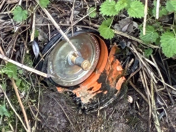
When we reported it to Anglian Water they responded very quickly and bunged up the pipe. They tell us that it can’t be sewage, because the iron levels in the gusher were very low (0.05mg/l) and they dose all the incoming sewage with iron to remove phosphates. They said they suspect its surface water or a land drain. This seemed a bit improbable to us, but still….one has to keep an open mind….
The Environment Agency visited Haslingfield Sewage Works on 10 March, and reported back to us a few days later, saying:
“Our Officers attended site on 10 March and we identified that that the EDM monitor (records when the storm tanks are spilling to the environment) was situated in a channel with standing water (storm sewage) which means that the probe continued to be in contact with the water even when no discharge was taking place from the storm tanks. This resulted in false activations of the EDM monitor and was recording false ‘spills’ to the environment. The monitor has been taken offline for this reason, and AWS are scoping solutions to allow them to accurately record spills from the storm tanks
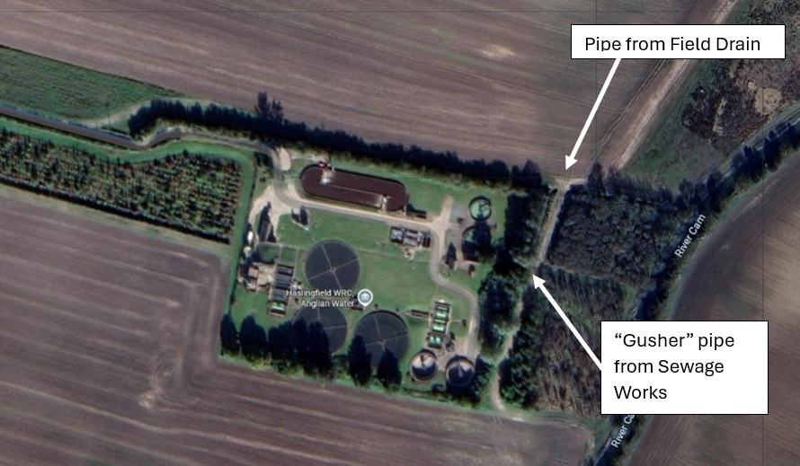
We also observed the small pipe as shown in the photographs attached to your email. The pipe comes directly from the boundary of the STW. This pipe has the appearance of a land drain. AWS Ltd bunged off the pipe, which led to water backing up on their site within cabling ducts and manholes. To alleviate this problem AWS are currently pumping the liquid that is backing up in the onsite manholes through the sewage works. AWS have tested this water, and it contains very low ammonia. It is possible that there could be a leak of final treated effluent wash water (used to wash screens etc.) that has made its way into the drain, or the water could be run off from farmland from beyond the site. AWS are going to conduct a drainage survey to try and determine where the liquid is coming from.
A Compliance Assessment Report (CAR) will be sent out and this be available on public register 28 days afterwards. CAR forms can be viewed using Environmental Permitting Regulations – Discharges to Water and Groundwater.”
We went back to check progress on 22 March and 1 April. The orange bung was still in place, but a few meters to the left, another old pipe was now furiously dripping water. There was no visible surface water around, (and we could see through the fence that the storm tanks were empty) so where’s this water coming from? Is it a leak of Anglian Water’s “wash water” or could it somehow be ground water, despite the dry weather?
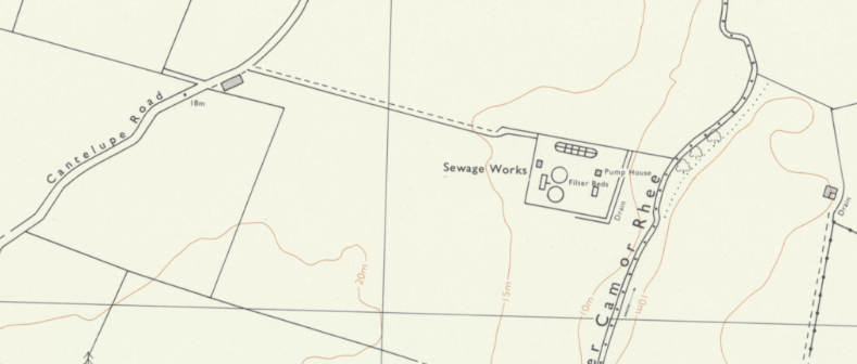
Looking around the site we spotted that there was a field drain emerging from the field just at the north east corner of the Sewage works.
Despite the dry weather this was flowing vigorously..
It seemed bizarre that so much water was coming out of an apparently dry field, so what was going on? Could it possibly be that springs have formed there? Or is it just that the fields still haven’t dried out at the depth of the field drain?
We’ve been told that since the nearby Cemex cement works at Barrington closed in 2008, and stopped abstracting water from the aquifer, various new springs have started forming in the area.
I did a bit of digging into historic maps available from the National Library of Scotland and Wow… The 1956 map marks a Spring, exactly at the site of the sewage works that was built a few years later
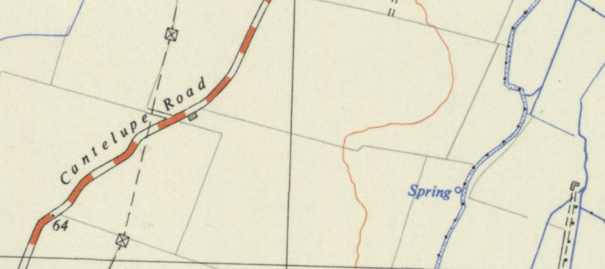
Today, this seems a really dumb place to have chosen for a sewage works, but in the late 1950s, could it have been deliberately sited there so the spring water would help wash out the treated sewage?
And today, is a re-emerging spring responsible for the water that’s now accumulating in Anglian Water’s cable ducts and manholes, escaping off-site through long-abandoned field drains? And could a re-emergent spring line be causing the repeated subsidence in Anglian Water’s channel, so the EDM sensors once again are sitting in a puddle, giving the false impression that there’s a storm overflow in progress?
Whoever it was that chose the site, this is now a problem for Anglian Water to fix..